Complete the Refuge
The Don Edwards San Francisco Bay National Wildlife Refuge currently protects 30,000 acres of wetlands, salt ponds, and other Bay habitats. The Refuge supports over 500 different fish and wildlife species, including numerous threatened and endangered species, while also providing a meaningful connection to nature for over 800,000 annual visitors.
While we celebrate the establishment, protection and enormous public support for the Refuge as it stands today, these 30,000 acres are just a small fraction of the hundreds of thousands of acres of wetlands that once surrounded San Francisco Bay prior to colonization, over 90% of which have been lost. In order to restore a healthy Bay, the scientific community has established a goal of protecting and restoring 100,000 acres of San Francisco Bay wetlands.
In 1985, realizing that important wetlands and habitats along the edges of the bay remained unprotected from development, the Citizens Committee to Complete the Refuge organized a grassroots campaign to expand the Refuge’s original boundaries. After several years of gathering support from all the cities and towns around the Bay, CCCR succeeded in 1988 when the U.S. Congress voted to authorize the Refuge to acquire (from willing sellers) or accept donations of an additional 20,000 acres of land to the Refuge up to 43,000 acres.
CCCR’s priority focus is permanently protecting these important wetlands and other habitats that are within the Refuge’s acquisition boundaries – before they are lost forever to development. This focus has taken on ever greater importance with climate change, as many of these areas are some of the few remaining uplands directly adjacent to Bay wetlands that will be needed in order to ensure that the wetlands and the wildlife that depend on them have a place to migrate to as sea levels rise.
The Missing Puzzle Pieces to Complete the Refuge
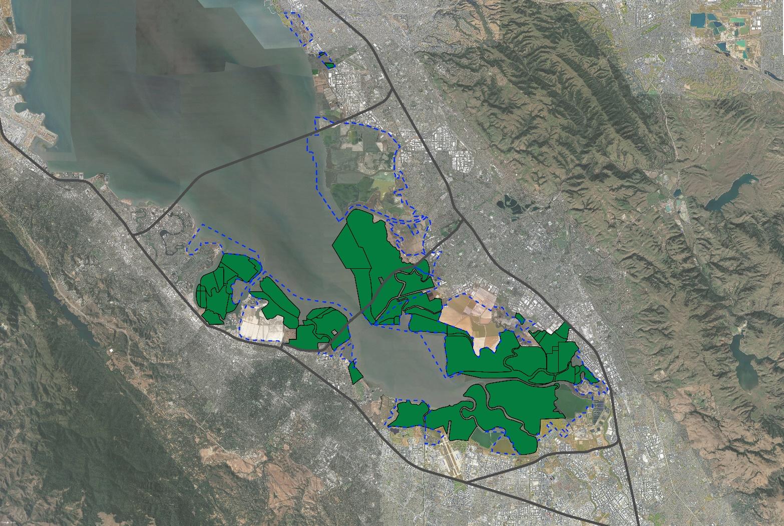
Citizens Committee to Complete the Refuge is currently focused on protecting the four largest areas that are within the Refuge’s acquisition boundaries but remain at high-risk of development. Those four areas are:
The Newark Area 4 baylands
(500 acres)
The Redwood City salt ponds
(1,436 acres)
The Newark Salt Ponds and Crystallizers
(3,000+ acres)
The Fremont-Coyote
Tract
(90 acres)
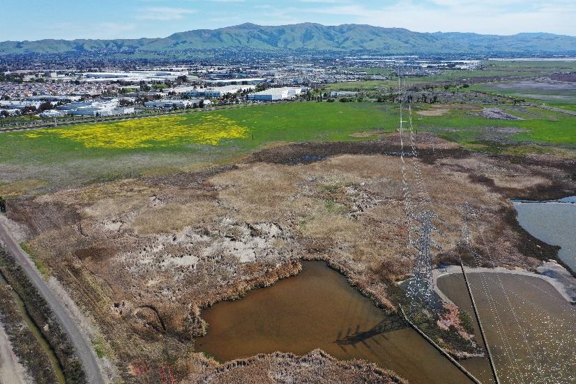
Newark Area 4
500 acres
Formerly home to the Whistling Wings and Pintail Duck Clubs, Newark Area 4 is an amazing mix of wetland habitats (seasonal, brackish, muted tidal) that grade landward to transition zone habitat and uplands. The site currently supports the federally-listed endangered salt marsh harvest mouse and provides habitat for resident and migratory waterbirds. Permanent protection of this site could expand important habitat and provide climate change resilience for tidal wetlands and for the adjacent communities of Newark and Fremont.
For decades, the San Francisco Bay scientific community has prioritized acquisition and restoration of the Newark Area 4 baylands, citing this site’s important role in supporting the long-term resilience of San Francisco Bay wetlands due to extremely-rare undeveloped upland areas where tidal wetlands can migrate with sea level rise.
Despite the overwhelming support for permanent protection of Area 4 by the scientific community, regional conservation and climate resilience organizations, these lands are currently threatened with two development proposals that would fill and develop the majority of the site. Stopping these developments is currently CCCR’s most urgent priority.
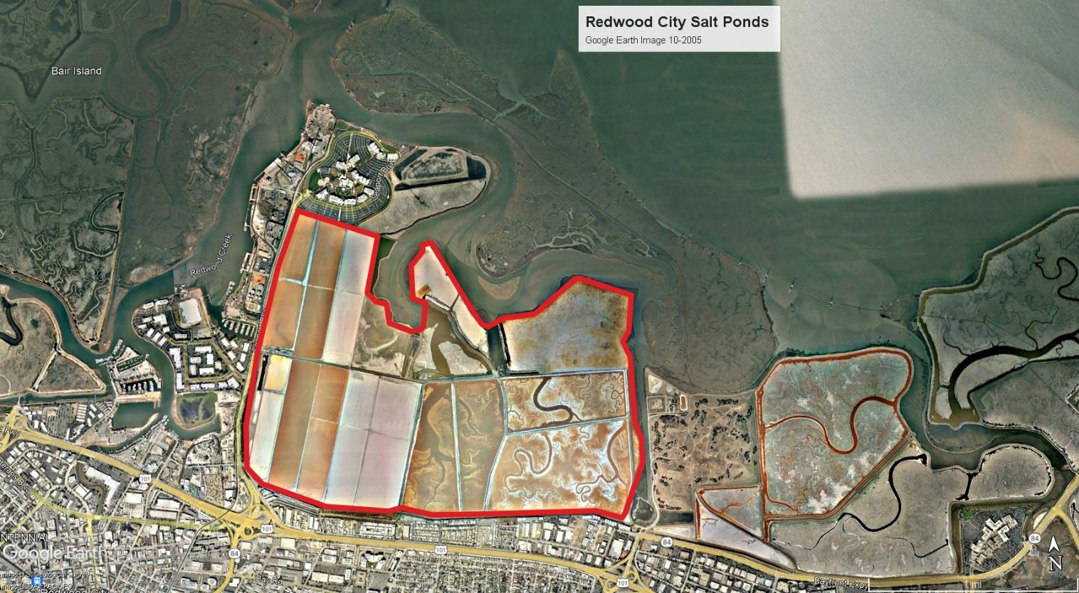
Redwood City Salt Ponds
1,433 acres
The Redwood City salt ponds represent an unrivaled opportunity to restore tidal wetlands along the San Mateo County shoreline. This site is unique due to its proximity to the Port of Redwood City and the potential for beneficial reuse of sediment dredged from Redwood Creek by the Port. The dredged sediment could be utilized for tidal wetlands restoration and after restoration, to elevate the marsh plain helping restored wetlands keep pace with rising sea levels. Restoration of tidal wetlands and high marsh habitat would expand the extent of available habitat for endangered species, and provide all the benefits that tidal wetlands create for wildlife and our communities including carbon sequestration and climate change resilience through flood protection.
However these lands are still owned by Cargill Inc., and Cargill worked with an Arizona-based development company in 2009 to try and develop the Redwood City salt ponds into a new bayside city of 30,000 people. After a multi-year campaign led by Save The Bay and supported by CCCR and many other organizations, this “Saltworks” project was defeated. However, Cargill has yet to indicate their willingness to sell or donate these salt ponds so that they can be restored back to San Francisco Bay wetlands. In the meantime, thousands of migratory shorebirds continue to happily forage on the site annually.
Watch this 3-minute video of CCCR Board Members Gail Raabe and Matt Leddy, who have worked for decades to protect the Redwood City salt ponds for a sense of what’s at risk and the community’s conservation vision.
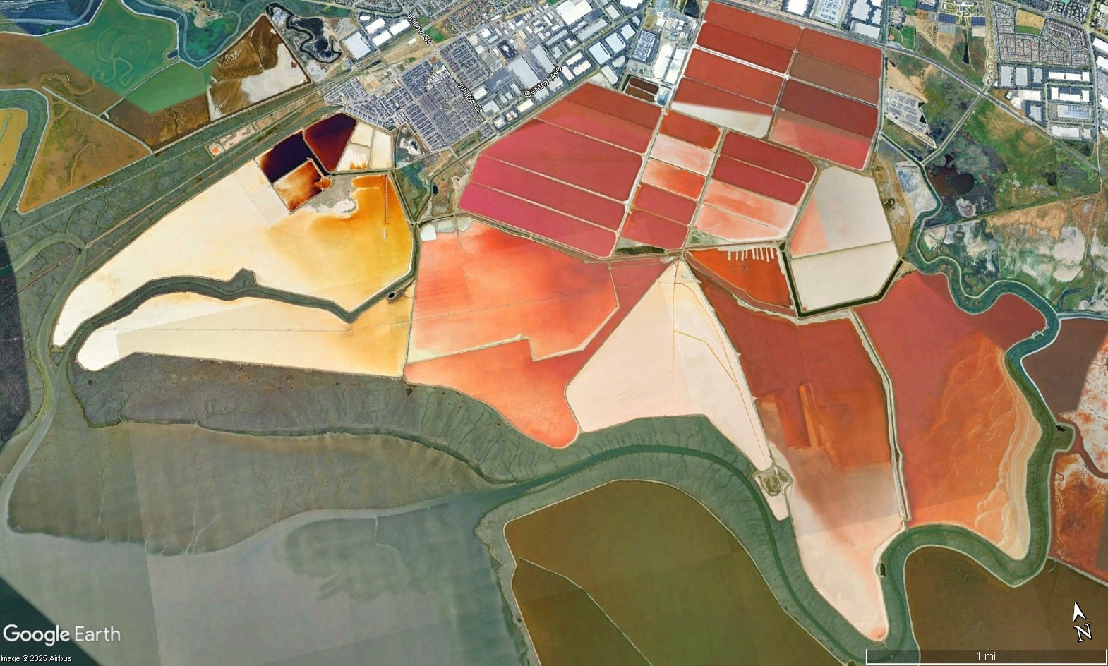
Newark Salt Ponds and Crystallizers
3,000+ acres
Historic Bay wetlands diked off and converted to commercial salt production prior to modern environmental laws, Newark’s 3,000+ acres of salt ponds and crystallizers are the single largest remaining unprotected baylands remaining in the South Bay. Located directly adjacent to large tracts of natural tidal marsh supporting endangered wildlife, the Newark and Mowry ponds have enormous potential for future restoration back to tidal wetlands, transition zone habitat and tidal wetlands migration space should current owner Cargill Inc. determine to stop salt production with these baylands.
As former wetlands, studies have shown that the Newark and Mowry ponds are at just the right elevation levels where they have the potential to quickly redevelop tidal marsh should salt-making cease, with less sediment input than other restoration areas of the Bay (an important factor for wetland restoration projects, given dwindling sediment supplies to San Francisco Bay), and are also likely to regenerate stable tidal marsh in the face of accelerated rates of sea level rise. This is particularly important, as sea level rise threatens to drown other established wetland areas around the Bay, and it is critical to the future health of the Bay to identify and protect areas like these that can support wetlands at higher water levels.

Fremont-Coyote Tract
90 acres
The Fremont-Coyote Tract is 90+ acres of privately-owned historic baylands directly between Coyote Hills Regional Park and the Refuge. While currently disconnected from historic tidal flows, surveys have indicated that over 80% of the site is still providing wetland functions, as indicated by the presence of endangered Salt Marsh Harvest Mouse documented in the pickleweed habitat on the site. A missing link in a corridor of protected wildlife habitat, this site has strong restoration potential, hydrologic function that could be restored, and would be a valuable addition to the Refuge. Loss of this site to development, however, would lead to destruction of valuable habitat, fragmentation of adjacent habitats and a reduction in the upland area where tidal marsh species may move up slope in response to rising sea levels.
We must continue to advocate for the permanent protection of these missing pieces of the Refuge, along with other at-risk baylands from development. The future biodiversity and health of San Francisco Bay depends on it!